GeoWerkstatt-Projekt des Monats Februar 2024
Projekt: A multi-scale and multi-sensor remote sensing approach for landslide analysis
Forschende: Magdalena Vassileva, Mahum Haghshenas, Mahdi Motagh
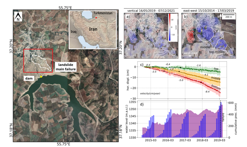
Projektidee: Landbewegungen in bergigem Gelände können in Satellitenbildern erkannt werden, so dass sich in Verbindung mit meteorologischen Daten Hangrutschungen vorhersagen lassen. In dem Projekt wird diese Idee anhand der Hoseynabad-e Kalpush Rutschung im Iran demonstriert.
Anthropogenic activities and extreme climatic events are increasing landslide hazards and related risks to human life, settlements and infrastructures worldwide. Investigating landslide kinematics and driving external factors and identifying potential precursors to landslide-failure is crucial for an effective hazard assessment and risk reduction. In-situ monitoring systems over landslide-prone slopes are often unavailable, making landslides challenging to detect and monitor in time and space. In this regard, global satellite missions with systematic acquisitions plans, such as Sentinel-1 and -2, provide a huge amount of data which allows performing both, retrospective and near real-time analysis.
 ©
IPI
©
IPI
In this work, we combine results from Envisat, Sentinel-1, PlanetScope and Landsat in a multi-variable satellite remote sensing approach analysed with advanced statistical methods to characterise the whole deformation field of the Hoseynabad-e Kalpush landslide in Semnan province, Iran, and investigate the role of meteorological and human factors that led to the catastrophic failure in March-April 2019. The landslide failure occurred following an exceptional precipitation period on the adjacent slope of a nearby reservoir built in early 2013. Influenced by the impoundment of the reservoir, a previously relict landslide was reactivated following a retrogressive destabilisation mechanism. The almost five years of landslide creep degraded the slope's geomechanical properties. The exceptional precipitation in spring 2019 increased in a short time the pore-water pressure within the slope, triggering a deep-seated landslide rupture. The outcomes of this study are relevant also for other settings where artificial reservoirs have been built adjacent to relict landslide-prone slopes and where no or only limited in-situ monitoring data are available.


