GeoWerkstatt-Projekt des Monats Juni 2022
Projekt: Updating geospatial database using deep learning
Forschende: Chun Yang
Projektidee: Mit modernen Methoden der Künstlichen Intelligenz bleiben die topographischen Datenbanken immer aktuell.
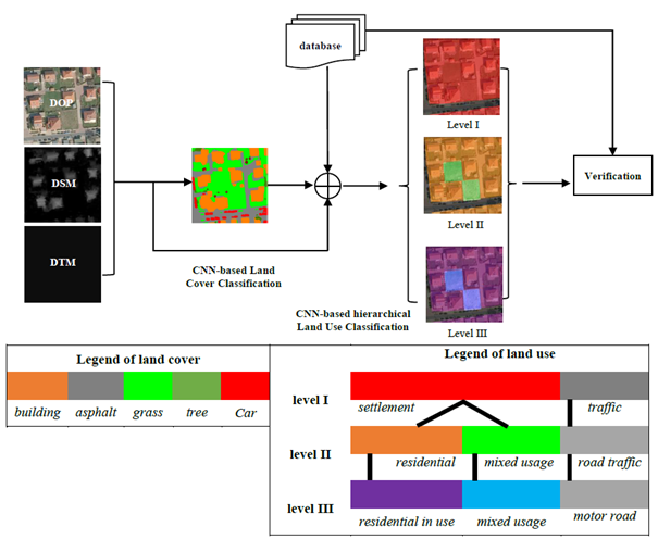
Geospatial land use databases contain important information with high benefit for several users, especially in the field of urban management and planning. Because of the fast changes of the land use due to urban growth and land use conversion, such geospatial databases become outdated quickly. This observation motivates us to develop an automatic update process for large-scale land use databases. Land use reveals the socio-economic function of a piece of land (e.g. residential, agricultural), land cover describes the physical material of the earth’s surface (e.g. grass, asphalt). The both terms of land cover and land use relate to themselves, which means, a land use object could contain many different land cover elements to form complex structures and meanwhile, a specific land cover can be a part of different land use objects. Thus, land cover and land use classification based on remote sensing data are tasks that pursue different objectives.
 ©
IPI
©
IPI
Generally speaking, the assignment of class labels to image sites is land cover classification, whereas the assignment of labels to larger spatial entities, typical functional units represented by polygons, is the goal of land use classification. In our project, we extract the land use and land cover information from high-resolution aerial images (see figure, left side). To achieve both goals with high quality results, we employ deep convolutional neural networks (CNN). Firstly, we do classification of land cover (semantic segmentation), and then use the generated land cover map as well as the original imageries to do classification of land use. In the stage of land use classification, we pursue hierarchical classification in multiple levels simultaneously while keeping consistent with the ALKIS catalogue (see figure). ALKIS is short for “Amtliches Liegenschaftskatasterinformationssystem” (Authoritative Real Estate Cadastre Information System).


