GeoWerkstatt-Projekt des Monats Juni 2025
Projekt: Räumlich-zeitliche Beobachtung und Analyse von Satellitenbildern zur Kartierung landwirtschaftlichen Flächen mit Hilfe von künstlicher Intelligenz
Forschende: Maryam Teimouri, Christian Heipke
Projektidee: Nutzung virtueller Label, um Deep Learning-Verfahren in der Beobachtung landwirtschaftlicher Flächen nutzen zu können, ohne dass genügend Trainingsdaten zur Verfügung stehen.
Agriculture is one of the major sources of food production, playing a crucial role in meeting the nutritional needs of the human population. On the other hand, mapping and monitoring crops are necessary, leading to the acquisition of up-to-date information about the crop types. This information plays a significant role in agricultural management.
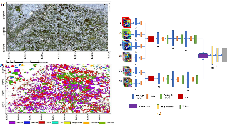
On the algorithmic side, convolutional neural networks (CNNs) are currently regarded as the most effective methods in image classification. These networks have demonstrated superior performance compared to traditional methods in various fields, such as the crop classification of crops from satellite images. However, CNNs require a vast amount of training data for effective network training. The collection and labeling of such data using traditional methods are both time-consuming and expensive.
To overcome this challenge and improve classification accuracy, we propose a method involving the generation of virtual training labels from real training labels. This research applies virtual labels alongside real labels for training 3D-CNNs, leading to an improvement in the classification accuracy of crops using the fusion of the European Earth Observation satellites Sentinel 1 and Sentinel 2 time series.
 ©
ipi
©
ipi
Publikationen
Teimouri M., Mokhtarzade M., Baghdadi N., Heipke C., 2023: Generating virtual training labels for crop classification from fused Sentinel-1 and Sentinel-2 time series. PFG (2023), 91:413.423, doi.org/10.1007/s41064-023-00256-w.


